Trend map with latitude profile
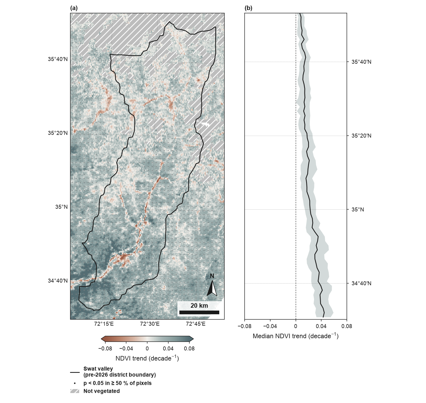
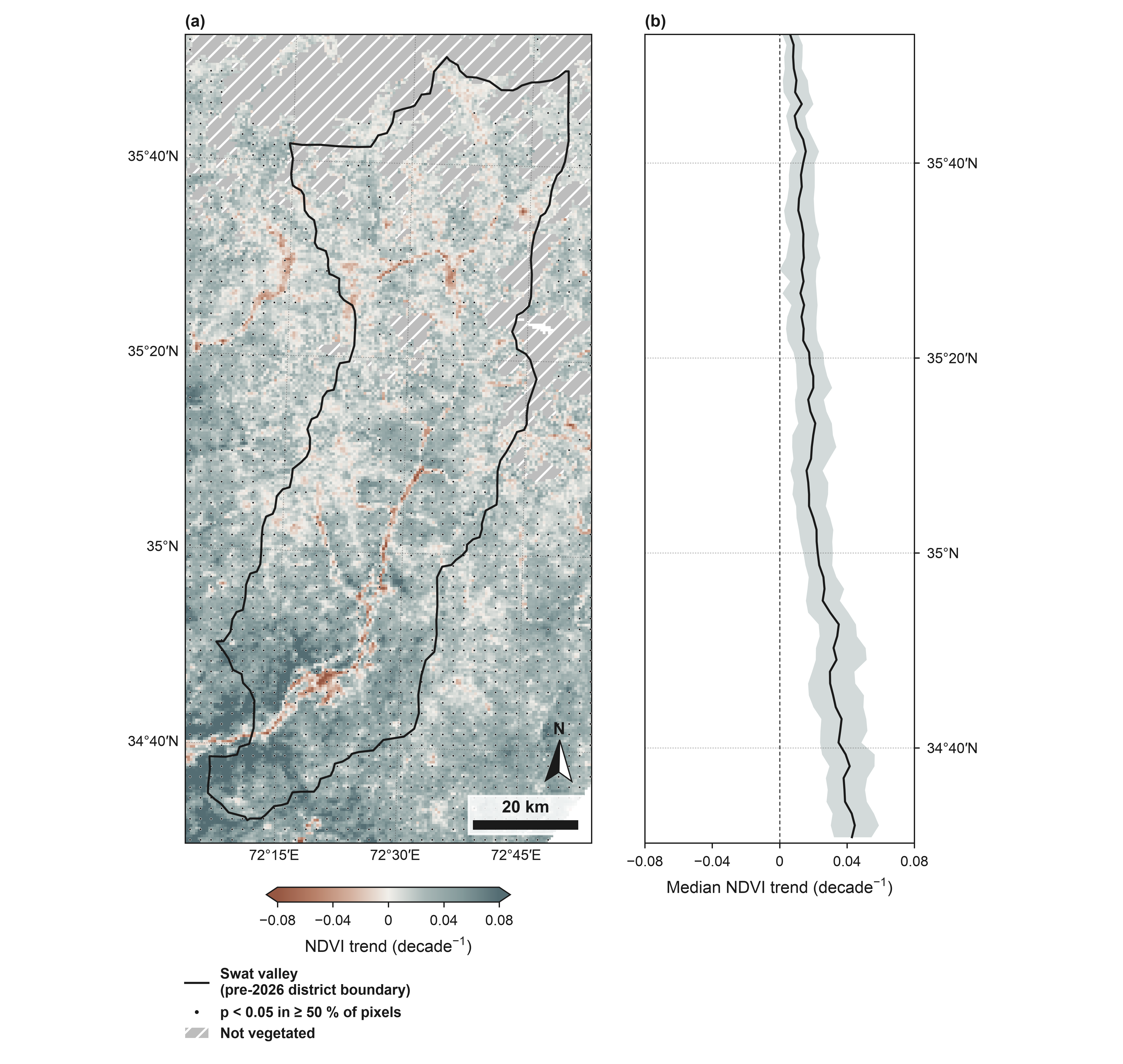
(a) Theil–Sen trend of growing-season NDVI (MODIS Terra MOD13A1 v6.1, 500 m, May–September median), 2001–2024, around the Swat valley (pre-2026 district boundary): the former Swat district (before January 2026), now Swat and Bar Swat (geoBoundaries). Dots: at least 50 % of 500 m pixels significant (Mann–Kendall, p < 0.05); the per-pixel tests assume serial independence and are not adjusted for multiple comparisons. Grey with diagonal hatching: mean NDVI below 0.1 over the record (not vegetated). (b) Median and interquartile range of the full-resolution slope in 0.02° latitude bands, vegetated pixels only, bands with at least 20 valid pixels; the bands line up with the map's latitudes. Greening is strongest in the south (lower valley) and weakens towards the high mountains in the north. MODIS data: NASA LP DAAC, accessed through the Microsoft Planetary Computer. Boundaries and names shown do not imply any opinion on the legal status of any country or territory.
from pathlib import Path

import pandas as pd
import rioxarray

import eofigs

DATA = Path(__file__).resolve().parents[1] / "docs" / "data" / "swat"


def swat_ndvi():
    """Load the annual growing-season NDVI cube (one band per year) with a time axis."""
    raw = rioxarray.open_rasterio(DATA / "swat_ndvi_growing_season_500m.tif", mask_and_scale=True)
    years = [int(year) for year in raw.attrs["long_name"]]  # band descriptions
    cube = raw.rename(band="time").assign_coords(
        time=pd.to_datetime([f"{year}-07-01" for year in years])
    )
    cube.name = "ndvi"
    cube.attrs = {"long_name": "NDVI", "units": "1"}
    return cube


eofigs.set_style("elsevier")
fig = eofigs.trend_map(
    swat_ndvi(),
    aoi=DATA / "swat_boundary.geojson",
    aoi_label="Swat valley\n(pre-2026 district boundary)",
    latitude_profile=True,
    width="double",
)

if __name__ == "__main__":
    print(fig.eofigs_layout["caption"])
    print(eofigs.save_figure(fig, "trend_profile_swat"))
Figure check
Figure check (elsevier): passed
  PASS  size: 190.0 x 180.0 mm (double width).
  PASS  resolution: 600 dpi (at least 500 for figures with text and images).
  PASS  font size: Smallest text 7 pt (minimum 7 pt).
  PASS  fonts: Fonts in use: Arial.
  PASS  colour-blind safety: 5 categorical colours, all distinguishable.
  PASS  colour maps: Colour maps: eofigs.terra_slate (diverging).