Large rasters
A map printed 90 mm wide at 600 dpi shows about 2 100 pixels across, however large the
raster is. fit_raster reduces a raster to the pixels the printed figure needs before it
is plotted, so very large rasters fit in memory, plot quickly and give small vector PDFs.
import eofigs

with eofigs.style("elsevier", font="serif"):
    fig, ax = eofigs.new_figure("single", height_mm=75)
    small = eofigs.fit_raster("dem_10m.tif", width_mm=90, height_mm=75, dpi=600)
    elevation = eofigs.variable("elevation")
    image = small.plot.imshow(ax=ax, cmap=elevation.cmap, add_colorbar=False)
    fig.colorbar(image, ax=ax, label=elevation.label, shrink=0.85)
    eofigs.save_figure(fig, "figures/fig1")
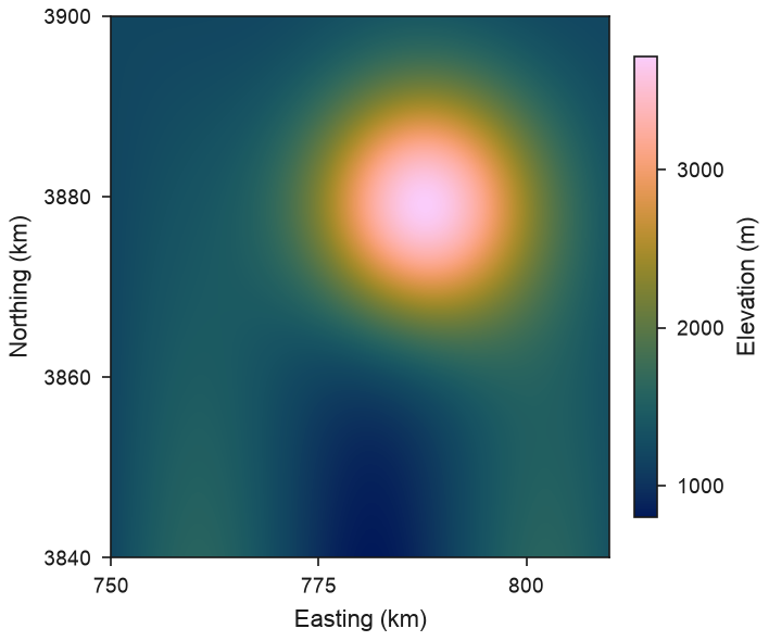
In this example a 6000 x 6000 raster (36 million pixels) becomes 2000 x 2000 pixels, the resolution of a 90 mm map at 600 dpi. The full script is on the gallery page.
How rasters are reduced
| Data | Reduction | Chosen when |
|---|---|---|
| Continuous values | mean of the valid source pixels | default |
| Classes (land cover) | most frequent class | kind="categorical", flag_values attributes, a GeoTIFF colour table, or a categorical library variable |
| Masks (for example p < 0.05) | fraction of True source pixels | kind="mask" or boolean data |
- Nodata and NaN pixels are ignored. An output pixel with fewer than
min_valid(default 0.5) valid source pixels is set to NaN. - Significance is never averaged as p-values. Reduce the significance mask instead
(
kind="mask"); the result is the fraction of significant source pixels in each printed pixel. Recipes dot a printed pixel when that fraction reaches a threshold (default 0.5). - The output always has at least as many pixels as the print needs, and rasters are never upsampled.
- The CRS is required and kept; the transform is updated to the new pixel size. eofigs never assumes a CRS.
Files and memory
GeoTIFFs and COGs are read with rasterio at the output size, so GDAL uses the file's
overviews when it has them and never loads the full-resolution array: a 10 000 x 10 000
GeoTIFF without overviews is reduced to a double-column map (4488 x 4488 pixels at 600 dpi)
in about 1.5 seconds. Pre-built overviews keep the resampling they were built with (often
nearest or average), which then applies instead of kind. For integer files (for example
8-bit masks or 16-bit DEMs), averages are computed exactly by eofigs, a few rows at a time,
because some GDAL versions round averages of integer data to whole numbers.
xarray inputs, including dask-backed arrays from rioxarray.open_rasterio(..., chunks=True),
are aggregated by an integer factor and stay lazy; up to factor - 1 edge rows and columns
(less than one printed pixel) are dropped so the grid stays regular.